The monument is located in the Upper Sonoran ecosystem, known
primarily for its characteristic saguaro cactus. Other common plants include: cholla,
prickly pear, hedgehog, and barrel cactus (blooming April through June); yucca, sotol, and
agave; creosote bush and ocotillo; palo verde and mesquite trees; an amazing variety of
colorful wild flowers (February through March); and a lush riparian area which supports
large Arizona black walnut, sycamore, and hackberry trees.
Animals native to Tonto National Monument include: whitetail and mule deer; mountain lion
and bobcat; javelina, porcupine, coyote, and ringtail; jackrabbit and desert cottontail;
several squirrel, chipmunk, and bat species; all four species of North American skunk;
three rattlesnake species; Arizona coral snake; over a dozen other snake species; Gila
monster and over a dozen other lizard species; four toad and frog species; and over 100
bird species. A paved trail to the Lower Ruin is self-guided (one mile round trip).
Guided tours to the Upper Ruin are available November through April (three miles round
trip) and require reservations. More trail information is listed
below.
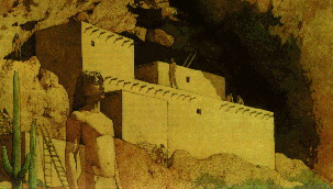
Tonto National Monument was established by President Theodore Roosevelt in 1907, one of
the first National Monuments to be proclaimed under the new Antiquities Act of 1906. Since
then, these pristine ruins have been both protected and open to the public to enjoy. Tonto
National Monument presents a unique opportunity to walk through the original rooms which
once housed a thriving community.
- VISITATION:
- 70,936 in 1995.
71,553 estimated for 1996
- LOCATION:
- Near Roosevelt, Arizona
- ADDRESS:
- HC02 Box 4602
- Roosevelt, AZ 85545
- TELEPHONE:
- Information: (520) 467-2241
- FAX: (520) 467-2225
- OPERATING HOURS, SEASONS:
- Daily, 8:00 a.m. - 5:00 p.m. except Christmas day. Lower Ruin Trail closes to uphill
travel at 4:00 p.m.
- CLIMATE, RECOMMENDED CLOTHING:
- Elevation: Visitor Center: 2,805 feet; Lower Ruin: 3,155 feet; Upper Ruin: 3,400 feet.
- Mild winters: lows in the 30s, highs in the 60s; hot summers, lows in the 70s, highs in
the 110s. Rainy seasons January/ February and July through September. Average annual
precipitation: 15 inches. Average days of sunshine: over 300. Average humidity during dry
seasons: 5-15%. Average humidity during rainy seasons: 30-50% (except when actually
raining!)
- The sun can be intense. Water, hats, and sunscreen are advised. Sturdy shoes or hiking
boots are recommended for the Upper Ruin Trail. Sneakers or other good walking shoes are
recommended for the Lower Ruin Trail.
- DIRECTIONS:
- Located on State Highway 88, immediately south of Roosevelt Lake.
- From Phoenix, take State Highway 60 (Superstition Freeway) east to Globe/Miami (75
miles); turn left (northwest) on State Highway 88; drive 30 miles to Tonto National
Monument entrance.
- From Scottsdale, take State Highway 87 (Beeline Highway) north to State Highway 188 (80
miles); turn right (southeast) on 188 and drive 35 miles to State Highway 88 (at Roosevelt
Dam); then drive four miles east on 88 to Tonto National Monument.
- A popular alternate route from Phoenix travels the Apache Trail. From Phoenix, take
State Highway 60 (Superstition Freeway) east to Apache Junction; take exit marked
"Apache Trail; Salt River Lakes; State Highway 88"; follow Apache Trail through
Apache Junction to Tortilla Flat, about 18 miles; about 4 miles northeast of Tortilla
Flat, the road becomes graded dirt for the next 24 miles to Roosevelt Dam. After passing
the dam, stay on 88 for 4 more miles east to Tonto National Monument. This route provides
some of the most spectacular scenery in Arizona, but is narrow, curved, and steep in
places. It is not advisable during wet weather.
- From Tucson, take State Highway 77 north to Globe (100 miles); at intersection of 77 and
State Highway 60, follow 60 through Globe to State Highway 88; turn right (northwest) on
88 and drive 30 miles to Tonto National Monument.
- From Flagstaff, take Forest Highway 3 (Lake Mary Road) to State Highway 87 (55 miles);
turn right (south) on 87 and drive 72 miles to State Highway 188 (17 miles south of
Payson); turn left on 188 (southeast) and drive 35 miles to State Highway 88 (at Roosevelt
Dam); then drive four miles east on 88 to Tonto National Monument.
- TRANSPORTATION:
- To Park: private vehicle.
- In Park: private vehicle, foot.
- Commercial tours may be available; check Yellow Pages in Arizona phone books under
"TOURS".
- FEES, COSTS, RATES:
- Entrance fee: $4.00 per car or $2.00 per bicycle/pedestrian; $50.00 Golden Eagle
Passport for all national parks; $10.00 Golden Age Passport (62 and over, U.S. Citizen;
lifetime pass) to all national parks.
- FACILITIES AND OPPORTUNITIES:
- Visitor Center/Exhibits:
One visitor center with exhibits and 12-minute orientation slide program; sales outlet for
interpretive literature; hands-on display; restrooms, vending machines for snacks and soft
drinks, public telephone. Parking lot has limited turning radius; vehicles longer than 30
feet and towing another vehicle experience difficulty negotiating the turn. Large vehicle
parking is available .5 mile below visitor center at picnic area.
- Picnicking:
Picnic area located .5 mile below visitor center (.5 mile inside park entrance); eight
tables, four covered with shade ramadas; one handicapped accessible. Currently pit toilet
facility, not accessible; construction begins in 1997 for fully accessible restroom.
- Trails, Roads:
Two trails: Lower Ruin (paved, .5 miles, ascends 350 feet, self-guided with booklet and
interpretive signs); Upper Ruin (dirt/rock, 1.5 miles, ascends 600 feet, ranger-guided
only). One mile park road from entrance to visitor center. Road is narrow with one steep,
hairpin curve immediately below the visitor center.
- Programs/Activities:
Guided tours to Upper Ruin, November through April; three to four hours, three miles round
trip; reservations required. Two to three tours given weekly, depending on staffing. Tours
limited to 15 people and often fill quickly; call for reservations early. Scheduled
walks and talks during busy visitor season, January through April. Junior Ranger
Program for children; complete activity booklet and earn badge and certificate.
Excellent opportunity for educational groups studying Southwestern archeology to visit
original dwellings; call in advance for special talks and tours, and for more information.
- Lodging and camping facilities:
None at the monument.
Adjacent Tonto National Forest has
several developed campgrounds within ten miles. Lodging available in nearby Roosevelt
(8 miles), Tonto Basin (16 miles), Globe/Miami (30 miles), and Payson (55 miles).
Food/gas/supplies:
Snack vending machines only at the monument.
Several convenience stores located within 15 miles of park, some with gasoline. Grocery
stores, vehicle mechanics, and other amenities in Globe/Miami, Tonto Basin, and Payson.
Other Concessions/NPS-Managed Visitor Facilities and Opportunities:
None.
Accessibility:
Lower level visitor center (museum exhibits, sales area, ranger assistance, rest rooms,
orientation program on video by request).
- RECOMMENDED ACTIVITIES/PARK USE:
- Hike Lower Ruin Trail and visit Lower Ruin; view orientation slide program and exhibits;
participate in interpretive activities when scheduled.
- RESERVATIONS/PERMITS:
- Reservations required for Upper Ruin tour; see "Programs/
Activities" section for details. Entrance fee applies; no extra charge for tour.
- BASIC VISIT/TIME RECOMMENDATIONS:
- Driving time from Phoenix, Scottsdale, or Tucson: 2.5 to 3 hours; from Flagstaff: 3 to
3.5 hours.
- Time to view orientation program and exhibits and hike to Lower Ruin: 1 to 2 hours.
- Time to participate in Upper Ruin tour: 3 to 4 hours.
- SPECIAL EVENTS, PROGRAMS:
- "Open House" annually on one weekend in March (participation in Arizona
Archeology Month) and first weekend in November. Visitors may hike to Upper Ruin on their
own, with park staff and volunteers providing assistance and interpretive programs.
- ADJACENT VISITOR ATTRACTIONS:
- Tonto National Forest surrounds the monument and offers trails, back roads, camping,
boating and fishing on Roosevelt Lake, hunting, and a visitor center with exhibits. Call
(520) 467-3200 for more information.
- Besh-Ba-Gowah is a superbly
reconstructed prehistoric Salado dwelling managed by the City of Globe. For information on
how to visit, call (520) 425-0320.
- ADDITIONAL INFORMATION:
- Call (520) 467-2241, between 8:00 a.m. and 5:00 p.m., seven days a week.
|